
GIS Project Management Platform
The most advanced management theory and technology with the world in the field of MePower Technology Co., Ltd. geographic information management, geographic information theory with mature model and rich development implementation capacity, the independent development of the geographic information project management Mepsoft GISPM products, it can be widely used in resource surveys, environmental assessment, disaster prediction, land management, city planning, telecommunications, transportation, military, public security, water conservancy and electric power, public facilities management, forestry and animal husbandry, statistics, business and finance in almost all areas.
Through years of focused development in the field of geographic information management, MePower Technology Co., Ltd. has a highly skilled and experienced expert team, able to provide users with high-quality project implementation, continuous technical support, rapid emergency response and professional consulting services.
MepSoft GISPM has the following six advantages:
- By using component oriented SOA architecture, multi-layer component model and XML data bus technology, according to the common demand of engineering project management, we initially realized the professional component library, and chose the component assembly system according to the needs of users.
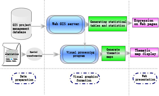
- With multi-layer structure design, when the business and traffic increased, the deployment server can be deployed in the middle tier. The front end will increase the deployment of Web server to improve the response to the client, and all changes will be transparent to the client.
- Integration (EAI) technology, portal technology, content management technology, search engine technology and metadata management technology are applied to build portal platform, and complete the development and deployment of advanced functions such as information presentation, statistical analysis and other basic functions, such as interactive collaboration and decision analysis.
- Using ESRI's ArcGIS as GIS development and service platform, and the system can be seamlessly integrated within other platforms, support for the latest AJAX technology, support the massive spatial database access, can provide WebGIS roaming fast and conform to the requirements of the system to provide geospatial application service.
- The data warehouse technology is combined with Sql Server 2005 business intelligence and report service function to provide support for project management data analysis.
- Use centralized storage and service to reduce the complexity of deployment and maintenance.
-
Software Product Series
- MepSoft International Material Management Platform
- MepSoft Party Affairs Construction Management Information System
- Port Logistics Management Information System
- EPC Engineering Management Information System
- Information Security Management Platform
- Training and Examination Management Platform
- Health Management Information System
- Scientific Research Project Management Information Platform
- MepSoft Rubbing Project Management Platform
- Overseas Account Management System
- Cloud Knowledge Management Platform
- GIS Project Management Platform
- CFCA Tianjin service provider
- M-ERP overall solution
- Intelligent City Visualization Platform
- MepSoft E-commerce platform
-
MepSoft Software Technology Series
-
Enterprise Software Customization and Outsourcing